Airport Services
| Fuel available: | 100LL 100LL:SELF SERVE 100LL FUEL AVBL 24-7. |
| Parking: | Tie-downs |
| Airframe service: | MAJOR |
| Powerplant service: | MAJOR |
| Bottled oxygen: | NONE |
| Bulk oxygen: | HIGH/LOW |
Site Information
| FAA Identifier: | REI |
| Lat/Long: | 34-05-06.9000N 117-08-47.0000W 34-05.115000N 117-08.783333W 34.0852500,-117.1463889 (estimated) |
| Elevation: | 1574.4 ft. / 479.9 m (surveyed) |
| Variation: | 14E (1995) |
| From city: | 2 miles NE of REDLANDS, CA |
| Time zone: | UTC -7 (UTC -8 during Standard Time) |
| Zip code: | 92374 |
Airport Operations
| Airport use: | Open to the public |
| Activation date: | 02/1947 |
| Control tower: | no |
| ARTCC: | LOS ANGELES CENTER |
| FSS: | RIVERSIDE FLIGHT SERVICE STATION |
| NOTAMs facility: | RAL (NOTAM-D service available) |
| Attendance: | 0800-1700 |
| Pattern altitude: | 2503.4 ft. MSL TPA – 929 FOR FIXED WING ACFT, N SIDE OF RWY 08/26; 500 FOR HEL, S SIDE OF RWY 08/26. |
| Wind indicator: | lighted |
| Segmented circle: | yes |
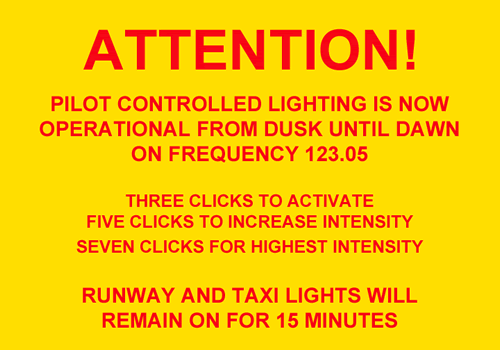
| Lights: | ACTVT REIL RWYS 08 & 26; PAPI RWY 08; MIRL RWY 08/26 – CTAF. |
| Beacon: | white-green (lighted land airport) Operates sunset to sunrise. |

Runway Information
| Dimensions: | 4504 x 75 ft. / 1373 x 23 m | ||||
| Surface: | asphalt, in good condition | ||||
| Weight bearing capacity: |
| ||||
| Runway edge lights: | medium intensity | ||||
| RUNWAY 8 | RUNWAY 26 | ||||
| Latitude: | 34-05.113665N | 34-05.118037N | |||
| Longitude: | 117-09.228998W | 117-08.336917W | |||
| Elevation: | 1471.7 ft. | 1574.4 ft. | |||
| Traffic pattern: | left | right | |||
| Runway heading: | 076 magnetic, 090 true | 256 magnetic, 270 true | |||
| Markings: | basic, in good condition | basic, in good condition | |||
| Visual slope indicator: | 2-light PAPI on left (3.00 degrees glide path) | ||||
| Runway end identifier lights: | yes | yes | |||
| Touchdown point: | yes, no lights | yes, no lights | |||
| Obstructions: | 4 ft. fence, 300 ft. from runway, 125 ft. left of centerline, 25:1 slope to clear | 60 ft. trees, 1500 ft. from runway, 120 ft. left of centerline, 22:1 slope to clear | |||